Quick answer: Baniyakund is an open meadow camp at 2,610 m (8,562 ft), about 4 km before Chopta on the road from Ukhimath. On Trekkaro's 5-day Chopta Chandrashila trek you walk in on Day 3, sleep there on nights 3 and 4, and start the Tungnath and Chandrashila summit day from this camp.
Where is Baniyakund, and how high is it?
Baniyakund lies on the road from Ukhimath, about 4 km short of the Chopta road point, so by road you pass it just before Chopta; on the trek you arrive on foot. Trekkaro's camp there is at 2,610 m (8,562 ft), only 69 m below Chopta at 2,679 m (8,790 ft). It is the highest place you sleep on the Chopta Chandrashila Trek: summit day climbs to Chandrashila at 3,962 m (13,000 ft) and then comes back down to the same meadow.
The table shows where Baniyakund sits among the other points of the trek.
| Point | Height | What happens there |
|---|---|---|
| Sari | 2,012 m / 6,601 ft | Night 1, end of the Day 1 drive |
| Deoriatal | 2,390 m / 7,841 ft | Night 2, camp about 200 m from the lake |
| Baniyakund | 2,610 m / 8,562 ft | Nights 3 and 4, the highest camp |
| Chopta | 2,679 m / 8,790 ft | Start of the summit walk on Day 4 |
| Tungnath | 3,680 m / 12,073 ft | Temple on the way up |
| Chandrashila | 3,962 m / 13,000 ft | Top of the trek |
How do you reach Baniyakund on the trek?
You arrive on foot. Day 3 is the long forest day: about 16 km from Deoriatal (2,390 m) in 7 to 8 hours, with a net gain of about 220 m. The trail crosses the wide meadow of Rohini Bugyal, then follows forest ridges and small clearings before it descends gently to Baniyakund. The ridges include steep descents that are hard on the knees, so keep your poles out after the meadow. Our Rohini Bugyal guide covers the meadow itself.
Day 1 is the 185 km drive from Rishikesh to Sari (8 to 9 hours), Day 2 is the 3 km walk to Deoriatal, and the group reaches this camp on Day 3.
What is the camp at Baniyakund like?
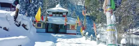
The campsite is a wide, open meadow with snow peaks behind it, and on a clear evening the sun drops behind those summits before dinner. Trekkaro pitches its own camp here for both nights. Tents are shared by three trekkers, with men and women in separate tents, and sleeping bags are rated to -20°C. Meals are pure vegetarian and are served in a large mess tent with tables; drinking water is hot water from the mess tent, so bring one insulated bottle.
What happens at Baniyakund on summit day?
Day 4 is the biggest day of the trek, 11 km on foot in 8 to 9 hours. You leave Baniyakund early for the short drive of about 4 km to Chopta, then walk about 3 to 3.5 km to Tungnath (the temple committee gives 3 km) and about 1 km more to Chandrashila. That is about 1,280 m up from Chopta and the same down.
Groups reach Chandrashila between 9 and 10 AM and stay 30 to 45 minutes. Keep your cap and gloves on at the top, even for photos. You then retrace your steps to Tungnath, take the steep upper section slowly on the way down, descend to Chopta and return to camp at Baniyakund for a hot dinner. The Tungnath trek distance guide breaks the walk into its stretches.
How cold is Baniyakund, and when is there snow?
Trekkaro runs the trek from October to June, with no batches in July, August and September. Camp nights follow the trek's figures: in December to February nights fall to -10°C to -6°C. Our Chopta and Tungnath weather guide has the full month table.
Snow lies on the higher sections from December to April. Trekkaro's trek leaders note that the snow is deepest in January on the climb from Baniyakund to Chandrashila, that February is the month the team rates highest because the snow is at its best for walking and the trail is quieter, and that the trail is busiest in the last part of December, the Christmas and New Year weeks. For live forecasts and warnings before you leave, check the India Meteorological Department's Dehradun centre.
Is there mobile signal or an ATM at Baniyakund?
Do not count on either. Sari is the last place on the trek with a stable mobile signal; beyond it the network is patchy to non-existent, and that includes both nights at Baniyakund. Make your calls in Sari and tell your family that you may be out of reach until the drive back on Day 5.
Rudraprayag has the last reliable ATM before Sari. Cards are not accepted on the trail, so carry cash in small notes for the cab share and anything you buy on the road.
How do you leave Baniyakund, and what does the trek cost?
The trek ends at Baniyakund. On Day 5 the cab leaves the camp early in the morning for the drive of about 200 km to Rishikesh (Jumping Heights, Tapovan), which takes 8 to 9 hours and arrives in the evening. Meals on the road are not included. Because the trek starts at Sari and ends here, luggage left at the start cannot be brought to the end: leave extra bags with your hotel in Rishikesh and carry what you need in one 50 to 60 L backpack.
The fee for the Chopta Chandrashila Trek is ₹8,250 per person plus 5% GST (₹8,662.50 with GST). EMI starts at ₹425 a month. It covers meals from Day 1 dinner to Day 4 dinner, tents, sleeping bags, ice axes, microspikes and gaiters, an oxygen cylinder, a first-aid kit and a stretcher with the group. Free Trekking Gear comes with it: Decathlon trekking shoes, a -10°C jacket, trekking poles, gaiters and microspikes, against a ₹3,000 refundable deposit and a ₹200 washing charge.
Transport is not included: we help the group book shared cabs at ₹6,500 one way per 5 to 6 seat vehicle, paid directly to the driver and split among trekkers, which is ₹1,083 each when six share. Every trekker brings a medical certificate signed by a doctor (the form is in My Bookings), and travel insurance is mandatory and not included; it must cover high-altitude trekking and emergency evacuation. The minimum age is 8, with a parent or guardian for anyone under 18.
See Chopta Chandrashila Trek dates and book | Rohini Bugyal | Chopta travel guide
Frequently asked questions
How far is Baniyakund from Chopta?
Baniyakund is about 4 km before Chopta on the road from Ukhimath. On the trek you cover that stretch by a short drive on the morning of summit day.
What is the height of Baniyakund?
Trekkaro's Baniyakund camp is at 2,610 m (8,562 ft). It is the highest camp on the Chopta Chandrashila trek, 69 m below Chopta.
Can you see snow peaks from Baniyakund camp?
Yes. The camp is a wide, open meadow with snow peaks behind it, and on a clear evening the sun sets behind those summits.
Is there snow at Baniyakund in winter?
Snow lies on the higher sections of the route from December to April. The deepest snow is on the climb from Baniyakund to Chandrashila in January.
Is altitude sickness a risk at Baniyakund?
The camp is at 2,610 m, and you come back down to it after the summit, so you never sleep higher than that. Your SpO2 and pulse are checked twice a day at every campsite, and the group carries an oxygen cylinder.