This guide is about the Satopanth Lake Trek — dates, price, day-by-day itinerary and booking are on the trek page.
Quick answer: Satopanth Lake (Satopanth Tal) is a small, three-cornered glacial lake at 4,600 m (15,100 ft) above Mana, near Badrinath in Chamoli district. On the Satopanth Lake trek it is about 20 km on foot from Mana, reached on Day 5 of 8 from the Chakratirtha camp at 4,150 m.
Where is Satopanth Lake, and how high is it?
Satopanth Tal sits at 4,600 m (15,100 ft) in a bowl of moraine above Mana, the last Indian village on the Badrinath road before the Tibet border. Mana is about 4 km up the valley from Badrinath, in Chamoli district, Uttarakhand.
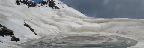
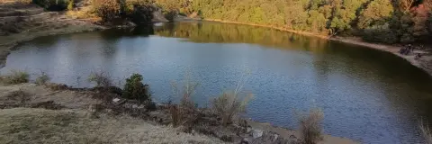
The trek page describes it as a small, almost perfectly triangular glacial lake, with the Satopanth glacier running down behind it and Swargarohini, Balakun and Chaukhamba around its rim. In May and June ice still floats on the surface; by September the water is a deep, clear green. The Chamoli district geography page names the Satopanth glacier as one of the two glaciers, with Bhagirath Kharak, from which the Alaknanda rises, 16 km upstream from Badrinath.
| Place | Height | What it is on the trek |
|---|---|---|
| Badrinath | 3,300 m | Guesthouse for the first two nights; acclimatisation day |
| Mana | 3,200 m | Village of stone houses where the walk starts, 4 km by road from Badrinath |
| Laxmi Van | 3,630 m (11,900 ft) | Camp beside a small birch grove, the last trees on the route; Days 3 and 6 |
| Chakratirtha | 4,150 m (13,615 ft) | High, bare camp on flat ground below the glacier; Days 4 and 5 |
| Satopanth Tal | 4,600 m (15,100 ft) | The lake; a day walk from Chakratirtha on Day 5 |
How far is Satopanth Lake from Mana and Badrinath?
On foot, the lake is about 20 km from Mana: 9 km to Laxmi Van, 7 km to Chakratirtha and about 4 km up to the lake, half of the 8 km round trip on Day 5. From Badrinath it is about 24 km: the 4 km drive to Mana, then about 20 km on foot. The whole trek is about 40 km on foot, because you walk the same trail back.
| Day | Route | On foot | Time | Height |
|---|---|---|---|---|
| 1 | Drive Rishikesh to Badrinath (about 300 km) | None | 10 to 12 hrs by road | 340 m to 3,300 m |
| 2 | Acclimatisation walks at Badrinath and Mana | Short walks | 2 to 3 hrs | About 3,300 m |
| 3 | Drive 4 km to Mana, walk to Laxmi Van | 9 km | 5 to 6 hrs | 3,200 m to 3,630 m |
| 4 | Laxmi Van to Chakratirtha via Sahastradhara | 7 km | 5 to 6 hrs | 3,630 m to 4,150 m |
| 5 | Chakratirtha to Satopanth Tal and back | 8 km | 6 to 8 hrs | 4,150 m to 4,600 m and back |
| 6 | Chakratirtha to Laxmi Van | 7 km | 3 to 4 hrs | 4,150 m to 3,630 m |
| 7 | Laxmi Van to Mana, drive to Joshimath (about 50 km) | 9 km | 3 to 4 hrs | 3,630 m to 3,200 m, then 1,890 m |
| 8 | Drive Joshimath to Rishikesh (about 255 km) | None | 9 to 10 hrs by road | 1,890 m to 340 m |
| Total on foot | About 40 km | 5 walking days | Highest point 4,600 m | |
The cabs are not in the trek fee: Trekkaro helps the group book shared cabs, paid directly to the driver and split among the trekkers, and your trek coordinator confirms the fare. The last reliable ATMs are at Joshimath; there is none at Mana or on the trail, and cards are not accepted there.
There is no luggage store on the trek: leave extra bags with your hotel or a friend in Rishikesh before the pickup, or at home, and carry only what you need in one 50 to 60 L backpack.
What do you pass on the way to the lake?
Day 3 follows the left bank of the Alaknanda out of Mana. About two hours in you pass Vasudhara, a tall waterfall that turns to spray before it reaches the ground. Then come moraine, boulder patches and a landslide-prone section, crossed one trekker at a time.
Day 4 passes Sahastradhara, a cliff face with dozens of thin falls running down it; the trek page gives the name's meaning as a thousand streams. Then come long stretches of boulder-hopping, glacial streams crossed on stones or shallow fords, and the climb onto the lateral moraine to Chakratirtha. Snow patches lie on this moraine in May and June.
The lake is held sacred in Garhwal, and the trek page records the local beliefs: its three corners are linked to Brahma, Vishnu and Shiva, the people of Mana have long consigned the ashes of their dead to its waters, and in the local telling the Pandavas passed this way on their final journey towards Swargarohini. There is no swimming or washing in the lake.
How hard is the day to the lake?
Day 5 is the hardest day of the trek. You leave Chakratirtha with a day pack and walk about 4 km each way, gaining 450 m over moraine and boulder fields and then a steep final ridge of loose moraine to the rim. The round trip takes 6 to 8 hours, including about an hour at the lake, and you sleep at Chakratirtha again.
The trek page grades Satopanth moderate to difficult because of its altitude and terrain; there is no technical climbing. It does not recommend this trek as a first Himalayan trek. It asks for at least one previous high-altitude trek and eight to ten weeks of training, and suggests the Pindari Glacier trek or the Kuari Pass trek first. The minimum age is 14, trekkers under 18 come with a parent or guardian, and trekkers over 60 are advised to bring an ECG or TMT report.
SpO2 and pulse are checked twice a day at every campsite; report any headache, nausea or breathlessness at once. Our guide to altitude sickness on Himalayan treks explains the warning signs.
When can you see Satopanth Lake, and how cold is it?
Trekkaro runs Satopanth from May to June and from September to October. In July and August monsoon rain blocks the Badrinath highway, and from November to April the lake and the upper route lie under snow and the road closes with the shrine. See the trek page for live batch dates.
| Months | Day temperature | Night temperature | At the lake |
|---|---|---|---|
| May to June | 20°C at Badrinath to 5°C at the lake | 8°C at Badrinath to -5°C at Chakratirtha | Ice floating on the water; snow patches on the moraine |
| September to October | 15°C to 0°C | 5°C to -10°C | Deep, clear green water |
Mobile signal works at Badrinath and Mana, is patchy up to Laxmi Van on some networks, and is absent at Chakratirtha and the lake; it returns at Mana on Day 7.
What should you check before you book the Satopanth Lake trek?
Ask any company these questions; the last column gives Trekkaro’s answers.
| What to check | Why it matters | With Trekkaro |
|---|---|---|
| Is there an acclimatisation day before the walk starts? | Badrinath is already at 3,300 m, and the lake is 1,300 m higher. | Yes. Day 2 is spent on short walks at Badrinath and Mana. |
| Who arranges the forest permit above Mana? | The area is under the Nanda Devi Biosphere Reserve and the Badrinath forest division. | Trekkaro arranges it and the fee is included; bring an original government photo ID and a photocopy. |
| Is gear for the cold included? | Autumn nights at Chakratirtha go down to -10°C, and there is snow on the moraine in May and June. | Free Trekking Gear: Decathlon trekking shoes, a -10°C jacket, trekking poles, gaiters and microspikes, with a ₹3,000 refundable deposit and a ₹200 washing charge; the deposit comes back within 7 working days. |
| What help travels with the group? | There is no signal at Chakratirtha or the lake. | SpO2 and pulse checks twice a day at every campsite; one oxygen cylinder and one stretcher travel with every batch. One trek leader or guide for every 8 trekkers, up to 20 per batch, trained in wilderness first aid. |
| What are the cancellation terms? | Monsoon rain blocks the Badrinath highway in July and August, and from November to April the road closes with the shrine, so a missed batch is hard to replace. | 70% back at 30 or more days, 50% at 15 to 29 days, no cash refund at 8 to 14 days and nothing at 7 days or less. Up to 8 days before, you can take a 100% TrekCash voucher (valid 1 year), one free reschedule or a transfer instead. |
What does the Satopanth Lake trek cost?
The Satopanth Lake trek fee is ₹22,500 per person plus 5% GST (₹23,625 with GST). EMI starts at ₹1,157 a month. Travel insurance is mandatory and not included. Every trekker brings a medical certificate signed by a doctor (the form is in My Bookings). Online booking closes at 5 PM (India time) the day before the batch starts. Full inclusions and live batch dates are on the Satopanth Lake trek page.
See Satopanth Lake Trek dates and book | Altitude sickness on Himalayan treks | Medical certificate for trekking
Frequently asked questions
What is the height of Satopanth Lake?
Satopanth Lake is at 4,600 m (15,100 ft), the highest point of the trek. The last camp below it, Chakratirtha, is at 4,150 m.
How far is Satopanth Lake from Mana?
The lake is about 20 km on foot from Mana, or about 24 km from Badrinath counting the 4 km road to Mana, over three walking days with camps at Laxmi Van and Chakratirtha. The whole trek is about 40 km on foot, out and back.
Is there snow at Satopanth Lake in May and June?
Yes. In May and June there are snow patches above Laxmi Van, on the moraine below Chakratirtha and around the lake, and ice floats on the water into June. Microspikes and gaiters come with the Free Trekking Gear.
Can a first-time trekker go to Satopanth Lake?
Trekkaro does not recommend it as a first Himalayan trek. It asks for at least one previous high-altitude trek and eight to ten weeks of training, and the minimum age is 14.
What should I look for when choosing a company for the Satopanth Lake trek?
Check that there is an acclimatisation day at Badrinath, that the lake day starts from the Chakratirtha camp and that the forest permit is arranged. Then compare the gear, the health checks, the 1:8 ratio and the cancellation terms.
Cover photo via Wikimedia Commons (cropped): Satopanth Tal: photo by Soumit ban, Public domain.