This guide is about the Kuari Pass Trek — dates, price, day-by-day itinerary and booking are on the trek page.
Quick answer: On a map, the Kuari Pass trek is a road to Pipalkoti (1,883 m) in Chamoli, a 15 km cab to Dhak (2,050 m), then a footpath through Gulling (2,900 m) and Khullara (3,350 m) to Kuari Pass (3,815 m), walked out and back. That is about 35 km on foot and about 1,765 m of climbing from Dhak.
What shape does the Kuari Pass route take on a map?
Draw the Kuari Pass Trek as a long road line that turns into a short footpath, and walk the footpath out and back. The road runs from Rishikesh to Pipalkoti and on to Dhak village, where it ends. From Dhak the trail climbs to two camps, Gulling and Khullara, and on summit day you walk from Khullara to the pass and back to the same tents. On Day 5 you come down the same forest trail to Dhak.
So the route is not a loop, and there is no second way down. That has two practical results: you sleep two nights at Khullara and carry only a day pack to the pass, and every point on the way down is a place you have already seen on the way up.
Where does the road end and the trail begin?
Day 1 is the drive from Rishikesh to Pipalkoti, about 215 km and about 9 hours; our guide to where Kuari Pass is covers the towns on the way.
On Day 2 a cab takes you 15 km from Pipalkoti to Dhak, a drive of about 40 to 45 minutes, and on Day 5 it brings you back. This cab is included in the trek fee. The drive between Rishikesh or Dehradun and Pipalkoti is not: we help the group book shared cabs at ₹6,500 one way per 5 to 6 seat vehicle, paid directly to the driver and split among trekkers, which is ₹1,083 each when six share.
What will you find at each point on the map?
The route map on the trek page marks Pipalkoti, Dhak, Gulling, Khullara and Kuari Pass, then Khullara and Dhak again for the return. The table adds what each point means on the ground: water, signal and what the trail is like. For the kilometres and hours of each day, see our Kuari Pass distance and height guide.
| Point | Height | What is there | Water and signal |
|---|---|---|---|
| Pipalkoti | 1,883 m | The base town, with the stays on Days 1 and 5 and Trekkaro's luggage store; there is no ATM | Jio and BSNL work, but the signal is spotty and depends on the weather |
| Dhak | 2,050 m | The trailhead, where the road ends | Fill your bottles here: water on the trail can be limited |
| Tugasi | Not marked | A village among terraced fields on the Day 2 trail, before the oak and rhododendron forest | Little or no signal on the trail |
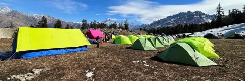
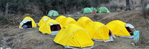
| Gulling | 2,900 m | The first camp, at the end of the forest climb from Dhak, with Garhwal peaks seen through the trees on the way | Hot water from the mess tent |
| Khullara | 3,350 m | The highest camp, reached past a small stream where the forest opens onto meadows; two nights here | Hot water from the mess tent; fill every bottle before summit day |
| Khullara Top | Not marked | 3.5 km from Khullara, across a broken bridge and a stream that freezes in winter | No water sources |
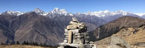
| Kuari Pass | 3,815 m (12,516 ft) | The pass, reached by a ridge climb from Khullara Top, with a 180° view of 14 peaks | No water sources |
Water is the detail a flat map hides. There are no water sources anywhere on the summit-day route, so on Day 4 you carry all your water from Khullara, with one insulated bottle so your water does not freeze.
How does the altitude profile rise and fall?
From Dhak the altitude chart climbs in three steps and comes down in two. The trail gains about 850 m to Gulling on Day 2, the biggest climb of the trek. Day 3 adds about 450 m to Khullara and is kept short so that your body can adjust. On Day 4 you gain about 465 m from Khullara to the pass and lose it again on the way back. Day 5 then takes you about 1,300 m down to Dhak in a single day, the longest descent, so use your trekking poles for your knees.
The pass stands about 1,932 m above Pipalkoti; on foot from Dhak you climb about 1,765 m. The highest place you sleep is Khullara at 3,350 m; the pass itself is visited on a day walk and not camped on.
Where on the map does the snow lie?
From December to March the forest is under thick snow. On the map, the snow matters most beyond Khullara: the stream before Khullara Top freezes, and the ridge to the pass becomes a snow climb. The snow is deepest on the climb from Khullara to the pass in January.
Microspikes and gaiters come free with the Free Trekking Gear, along with Decathlon trekking shoes, a -10°C jacket and trekking poles, against a ₹3,000 refundable deposit and a ₹200 washing charge. After fresh snowfall the team clears the trail and helps you across slippery sections, and on the ridge the group takes a short break every 15 minutes. Ropes are not needed on this trek. Before you travel, check the forecast for Chamoli district on the India Meteorological Department's Dehradun centre.
Which peaks can you see from which point?
Place the views on the map and they come in three stages. On Day 2 the Garhwal peaks show through gaps in the trees on the climb to Gulling. On Day 5, coming down from Khullara, snow peaks and meadows are around you. Only at the pass does the whole skyline open, a 180° arc of 14 peaks with Nanda Devi and Kamet among them.
Groups reach the pass between 9 and 10 AM and stay 30 to 45 minutes. Wind on the ridge can be strong, so pull on a layer at the top and keep your cap and gloves on, even for photos.
Can you navigate with the route map on the trek page?
No. The route map and altitude profile on the trek page are for orientation, not navigation, and your trek leader walks the trail with you. Use the map to see where each camp sits and how the height builds, and leave the route-finding to the leader and the local guides, above all when the ridge is under snow. With little or no mobile signal beyond Pipalkoti, the team uses radios on the trail.
What does the trek cost?
The fee for the Kuari Pass Trek is ₹9,400 per person plus 5% GST (₹9,870 with GST). EMI starts at ₹484 a month. It covers pure vegetarian meals from Day 1 dinner to Day 5 dinner, the stays in Pipalkoti and the tents at Gulling and Khullara, permits, the Free Trekking Gear and the Pipalkoti to Dhak cab on Days 2 and 5. Pipalkoti has no ATM, so carry cash in small notes from Rishikesh or Dehradun. Trekkaro runs the trek from October to April; see the trek page for live batch dates.
See Kuari Pass Trek dates and book | Is Kuari Pass trek safe | Kuari Pass weather
Frequently asked questions
Is the Kuari Pass trek a loop?
No, it is an out-and-back route. You walk from Dhak to Gulling and Khullara, go to the pass and back to Khullara on summit day, and return to Dhak on the same forest trail.
Where does the road end on the Kuari Pass trek?
The road ends at Dhak village, 2,050 m, 15 km from Pipalkoti. The cab between Pipalkoti and Dhak on Days 2 and 5 is included in the trek fee.
Where can I fill water on the Kuari Pass route?
Fill your bottles at Dhak, because water on the trail can be limited, and refill with hot water from the mess tent at each camp. There are no water sources on summit day, so carry all your water from Khullara.
What is the highest camp on the Kuari Pass trek?
Khullara, at 3,350 m, is the highest camp, and you sleep there two nights. Kuari Pass at 3,815 m is reached on a day walk from Khullara.
Which part of the Kuari Pass route has the deepest snow?
The climb from Khullara to the pass has the deepest snow, in January. From December to March the forest is under thick snow and the stream before Khullara Top freezes.