This guide is about the Kuari Pass Trek — dates, price, day-by-day itinerary and booking are on the trek page.
Quick answer: Kuari Pass (3,815 m / 12,516 ft) is in Chamoli district, Uttarakhand, in the Garhwal Himalaya. You reach it by road from Rishikesh to Pipalkoti on the Badrinath Road, 215 km and about 9 hours, then drive on to the trailhead at Dhak (2,050 m / 6,726 ft) and walk up past the Gulling and Khullara camps.
Where exactly is Kuari Pass?
Kuari Pass sits in Chamoli, the Uttarakhand district that the trek page names in its location line. The page also gives the route its older name: “Also known as the Curzon Trail, the Kuari Pass trek lies in the Chamoli district of Uttarakhand”. The pass itself is at 3,815 m, which the trek page gives as 12,516 ft.
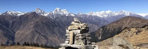
What the pass looks out on helps you place it. The trek page gives a 180° view of 14 peaks from the top, Kedarnath, Chaukhamba, Kamet and Nanda Devi among them, and along the route it names Dronagiri, Trishul, Bertholi, Hathi Ghodi Parvat, Mana and Neelkanth as well. The highest camp, Khullara, is at 3,350 m, so the pass is a day walk of 13 km up and back from the tents.
Which river and which towns does the road to Pipalkoti follow?
The Alaknanda. The Day 1 drive leaves Rishikesh on the Badrinath Road and climbs into the Garhwal hills with the Alaknanda beside you for much of the way; the trek page says the river grows louder as you climb. In order, you pass the confluences at Devprayag, Rudraprayag, Karnaprayag and Nandaprayag, the stretch the trek page calls the Panchprayag region on the way back. Small villages and roadside dhabas break up the journey.
The Chamoli district “How to Reach” page names Gopeshwar, Karnaprayag and Rudraprayag as the nearest major settlements to Chamoli, and says Chamoli lies on NH58. Karnaprayag and Rudraprayag are two of the confluence towns on your drive.
The trek page's packing notes add one more road fact: mobile signal is weak after Joshimath and mostly absent on the trail, so make your last reliable calls on the drive.
What lies between Rishikesh and the pass?
The table runs from the pickup point to the pass, with what each place is, its height on the trek page and how you reach it.
| Place | What it is | Height | How you reach it |
|---|---|---|---|
| Rishikesh (Jumping Heights, Tapovan) or Dehradun Railway Station | Pickup and drop points | Rishikesh 340 m / 1,115 ft | On your own |
| Pipalkoti | Base town on the Badrinath Road; the trek page calls it “known for its hot springs and apple orchards” | 1,883 m / 6,178 ft | 215 km by road from Rishikesh |
| Dhak | Trailhead village among terraced fields, where the walking starts and ends | 2,050 m / 6,726 ft | Drive from Pipalkoti |
| Tugasi | Garhwali village with terraced fields at the start of the trail | Above Dhak | On foot from Dhak |
| Gulling | Tucked-away campsite on the forest slope | 2,900 m / 9,514 ft | 6 km through oak and rhododendron forest |
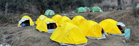
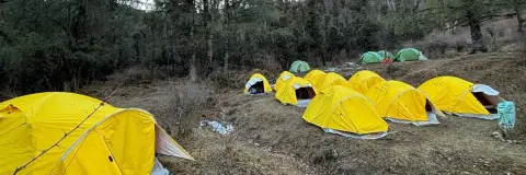
| Khullara | Camp among open meadows and coniferous forest, the highest place you sleep | 3,350 m / 10,991 ft | 5 km from Gulling, past a small stream |
| Khullara Top | Point on the summit-day route, past a broken bridge and a stream that freezes in winter | Between camp and the pass | 3.5 km from Khullara |
| Kuari Pass | Highest point, reached on Day 4 | 3,815 m / 12,516 ft | Ridge climb from Khullara Top; out and back from Khullara |
In all, the trek covers about 35 km on foot in four walking days. For the day-by-day split and the height of every stretch, read Kuari Pass distance and height.
What do you see from Kuari Pass?
The view builds in stages, and the trek page describes each one. Clearings in the forest above Dhak give the first sight of the Garhwal peaks. The meadows at Khullara open onto the ranges around camp. On summit day the first 3.5 km lead to Khullara Top, across the broken bridge and the stream, and then the ridge climbs towards the pass; there are no water sources on this route, so you carry everything you drink.
At the pass the ridge opens out and the peaks arrive together: fourteen summits in a single 180° arc, with Kedarnath, Chaukhamba, Kamet and Nanda Devi the four the trek page names first. The page points out that you get this panorama without going above 4,000 m, and that you come down the same evening to the same tents at Khullara, which is why the camp is used for two nights.
What should you know about Pipalkoti before you arrive?
Pipalkoti has no ATM, so draw cash in Rishikesh, Dehradun or your home city. Jio and BSNL work in the town, but the signal is spotty and weather-dependent, and on the trail it is little to none apart from short coverage on the first and last day. You stay in a guesthouse or homestay at Pipalkoti on Day 1 and Day 5, and the town has a few small shops for basic trekking items. Because the trek starts and ends there, you can leave extra luggage at the base before you set out, free of charge.
Fill every bottle at Dhak: the trek page warns that water sources are limited, and on summit day you carry all your water.
Is the cab to Pipalkoti included?
No: Trekkaro helps the group book shared cabs from Dehradun Railway Station or Rishikesh (Jumping Heights, Tapovan) to Pipalkoti and back, about ₹6,500 one way per 5–6 seat vehicle, paid to the driver and split among the trekkers. The pickup times, the return drive and the full cost picture are in Kuari Pass trek cost.
How far are the airport and railhead from Chamoli?
For the trek, the trek page points to Jolly Grant Airport (DED) at Dehradun, about 20–25 km and about 45 minutes from Rishikesh, and to Dehradun (DDN) or Haridwar Junction by train; it puts Haridwar about 25 km and an hour by road from Rishikesh, and notes that Yog Nagari Rishikesh (YNRK) has only a few trains. The Chamoli district page takes a district-wide view: Jolly Grant is the nearest airport to Chamoli, 222 km away, and Rishikesh the nearest railway station, 202 km before Chamoli. Those figures are given to Chamoli, not to Pipalkoti or Dhak.
Which months is Kuari Pass open?
The trek page's season line reads: October to April, with December to March the window for snow. From December to February the forests, meadows and the ridge to the pass are under snow and the stream below Khullara Top is frozen; in March the snow retreats from the lower trail while the rhododendrons bloom; October, November and April are the milder ends of the season. See the trek page for live batch dates.
The fee is ₹9,400 + 5% GST, which is ₹9,870 per person, Pipalkoti to Pipalkoti; the trek page lists what it includes and excludes.
See Kuari Pass dates and book | Kuari Pass difficulty and fitness | Kuari Pass weather
Frequently asked questions
Which district is Kuari Pass in?
Kuari Pass is in Chamoli district, Uttarakhand. It belongs to the Garhwal Himalaya.
Is there an ATM at Pipalkoti?
No. The trek page says there is no ATM at Pipalkoti, so bring cash for your cab share and small costs from Rishikesh, Dehradun or home. It also says mobile signal is mostly absent on the trail.
How far is Pipalkoti from Rishikesh?
Pipalkoti is 215 km from Rishikesh by road. Allow about 9 hours on the way up and 8–10 hours on the way back.
Which is the nearest airport to Kuari Pass?
Jolly Grant Airport at Dehradun, about 20–25 km from Rishikesh. The Chamoli district page gives it as 222 km from Chamoli, so plan to fly in the day before the drive.
What is the height of Kuari Pass?
Kuari Pass is at 3,815 m, given on the trek page as 12,516 ft. The highest camp below it, Khullara, is at 3,350 m.