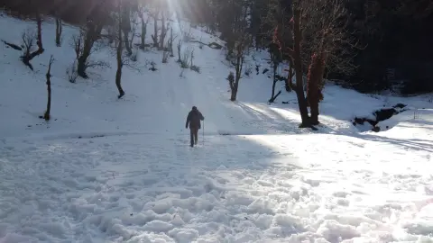
This guide is about the Kedarkantha Trek — dates, price, day-by-day itinerary and booking are on the trek page.
Quick answer: The Kedarkantha trek starts and ends at Sankri (1,950 m) on one trail, walked up and back: 4 km of forest to Juda Ka Talab (2,773 m), 3 km of meadow to base camp (3,429 m), then about 3 km to the 3,810 m summit, climbed from 2:00 AM. You walk about 20 km, heading almost due south.
Read this before you open the Route Map tab on the Kedarkantha trek page: it explains where the trail starts, what each leg is like, and what the map does and does not show. Altitudes, distances and times are from the trek page; straight-line distances and directions are our own calculation from its route-map pins.
Where does the Kedarkantha trek start?
The trail begins at Sankri village, 1,950 m (6,400 ft), in Uttarkashi district. Dehradun is where the group meets, not where the walking starts. The group's shared cab leaves Dehradun Railway Station at 6:30 AM on Day 1 and reaches Sankri, about 200 km away, in 7–8 hours. Transport is not included in the trek fee: we help the group book the shared cab, ₹1,000 per person each way (₹2,000 return), paid directly to the driver.
Purola, on the drive, has the last reliable ATM, and cards are not accepted on the trail, so carry small notes. Sankri is the last place with mobile signal, and only Jio works consistently there. There is no signal and no charging after Sankri, so download an offline map before you leave and carry a power bank.
The route at a glance
The table follows the trail in the order you walk it. Walked distance and time are the itinerary's figures. Straight-line distance and direction are measured between the camp pins on the trek page's route map, so you can see how much the trail winds.
| Leg | From → to | Altitude reached | Walked | Straight line and direction | Terrain |
|---|---|---|---|---|---|
| 1 (Day 2) | Sankri → Juda Ka Talab | 2,773 m / 9,100 ft | 4 km, 4–5 hrs | 2.9 km, south-southwest | Pine and oak forest |
| 2 (Day 3) | Juda Ka Talab → Base Camp | 3,429 m / 11,250 ft | 3 km, 2–3 hrs | 1.3 km, south-southwest | Open meadows and snow slopes |
| 3 (Day 4) | Base Camp → Summit | 3,810 m / 12,500 ft | About 3 km, from 2:00 AM | 2.1 km, south | Steep switchbacks, deep snow in winter |
| Return (Day 4) | Summit → Base Camp → Juda Ka Talab | Down to 2,773 m | About 6 km | Same line back | Same trail down |
| Return (Day 5) | Juda Ka Talab → Sankri | Down to 1,950 m | 4 km, 3–4 hrs | Same line back | Pine forest |
| Total | Sankri → Summit → Sankri | 3,810 m | About 20 km | 6.2 km each way | One trail, walked both ways |
The route heads south from Sankri, each camp further south and higher. You walk about 10 km to cover 6.2 km of map distance because the trail winds and switches back up the slope.
What is each leg of the route like?
Leg 1: Sankri to Juda Ka Talab (Day 2)
From the village the path climbs steadily into pine and oak forest, laden with snow in winter. The trek page calls the gradient consistent and manageable. This leg has the biggest height gain of the trek, 823 m, an average of about 205 m for each kilometre walked. The camp is pitched beside Juda Ka Talab, a high-altitude lake that freezes solid in winter.
Leg 2: Juda Ka Talab to Base Camp (Day 3)
The shortest walking day, 2–3 hours, but the steepest on average: 656 m up in 3 km, about 220 m per kilometre. The forest opens into a chain of alpine meadows, under snow in winter. From this stretch the trek page names Swargarohini, Black Peak, Ranglana and Bandarpunch as visible on a clear day.
Leg 3: Base Camp to the summit and back (Day 4)
Your guide wakes the tents at 2:00 AM. You climb about 3 km by headlamp, with the temperature well below freezing. On paper this leg is the gentlest, 381 m of gain, but the average hides the hard part: the trek page describes the summit trail as steep and unrelenting in places, cutting through deep snow on switchbacks. In winter, microspikes, handed out at the gear check in Sankri with Free Trekking Gear, go on for summit day. At sunrise Swargarohini, Black Peak, Bandarpunch and Kalanag catch the first light.
The way down is the same trail. You are back at base camp by mid-morning, then keep descending through the meadows to Juda Ka Talab by late morning. Day 4 adds up to about 9 km and 8–9 hours, the longest day of the trek.
Back to Sankri (Day 5)
The last 4 km is the forest descent you climbed on Day 2. There is no loop and no second village on the way down: you retrace the trail you know, and the trade-off is that the last day shows you nothing new. The trek ends at Sankri, where completion certificates are given out, and the cab is expected back at Dehradun Railway Station by 6:00 PM.
How does snow change the route through the season?
The trail is the same all season; the ground changes. From December to February it is under deep snow from the forest to the summit, and microspikes are worn on summit day. In March and April snow stays on the upper sections while the lower forest trail clears. May and June are snow-free, July and August are closed for the monsoon, and from October the first snow reaches the peaks above green meadows.
Our batches this season run from 24 October 2026 to the end of February 2027: 3 starts in October, 9 in November (Saturdays and Sundays), then one start each day of December, January and February. No batches are listed after February yet.
How do you use the route map on the trek page?
Open the Route Map tab on the Kedarkantha trek page and you see six pins: Sankri, Juda Ka Talab, base camp, the summit, Juda Ka Talab again and Sankri, each with its altitude and day. Its line joins 613 points taken from mapped footpaths and the Trekkaro route. Treat it as a sketch of where the trail goes: the page marks it for orientation, not navigation, and it is not a GPS recording.
Use it to see how close the camps are and where the climbing is. On the trail you follow your trek leader, not a screen; batches take a maximum of 20 trekkers, with one leader or guide for every 8.
The Uttarakhand Health Department's high-altitude advisory for travellers going above 3,000 m advises no more than 800–1,000 m of elevation gain a day. On this route your sleeping height rises 823 m on Day 2, to 2,773 m, just over the lower figure but still below 3,000 m, and 656 m on Day 3, to 3,429 m. The summit is a climb from camp, not a move to a higher camp. If you feel unwell, the advisory says descend and do not go higher. On our batches, SpO2, pulse and blood pressure are checked twice a day at each campsite, and each batch carries a portable oxygen cylinder and an emergency stretcher.
What it costs
| Item | Amount |
|---|---|
| Trek fee (Sankri to Sankri) | ₹9,000 per person |
| GST at 5% | ₹450 |
| Total | ₹9,450 |
| EMI | The trek page shows EMI from ₹463 a month |
| Shared cab Dehradun–Sankri | ₹1,000 per person each way (₹2,000 return), paid to the driver |
| Free Trekking Gear deposit | ₹3,000, refundable, plus ₹200 washing charge (+ GST) |
| Backpack offloading (optional) | ₹1,500 + GST, up to 9 kg |
| Single tent (optional) | ₹2,000 + GST |
The fee covers the Sankri guesthouse on Day 1, tents on Days 2–4 (shared by three, men and women separate) with sleeping bags rated to −20°C, meals from Day 1 dinner to Day 5 breakfast, and Govind Pashu Vihar National Park permits. Kedarkantha comes with Free Trekking Gear: Decathlon trekking shoes, a −10°C jacket, trekking poles, gaiters and microspikes. Carry a government photo ID (original and a copy) and a medical fitness certificate signed by a doctor. Travel insurance covering high-altitude trekking and helicopter evacuation is mandatory and not included. Ask your doctor about altitude medicine, including Diamox, before you come. Pack a headlamp, a power bank kept close to your body and two 1-litre bottles, one insulated, and refill only at points your trek leader confirms as safe. Booking closes at 5 PM (India time) the day before the batch starts.
Plans change. Cancel 30 or more days before departure and you get 70% back; at 15–29 days, 50%. At 8–14 days there is no cash refund. At any point up to 8 days before departure you can take a 100% TrekCash voucher (valid one year), a free reschedule or a transfer to another trekker instead of the cash refund. At 7 days or less, or a no-show, there is no refund.
See Kedarkantha dates and book | Kedarkantha distance and height | Where is Kedarkantha? | How to reach Sankri
Frequently asked questions
Which direction does the Kedarkantha trail go from Sankri?
Close to due south. By the route-map pins, Juda Ka Talab, base camp and the summit all lie on a bearing of about 192° from Sankri, just west of south; the summit is 6.2 km away in a straight line. The trail winds, so you walk about 10 km to get there.
Is the route map on the trek page good enough to trek Kedarkantha on my own?
No. The line is drawn from mapped footpaths and the Trekkaro route, not recorded by GPS, and the page says it is for orientation only. There is also no mobile signal after Sankri to fall back on if you lose the trail.
Which part of the Kedarkantha route is the steepest?
By average gain, Juda Ka Talab to base camp climbs the most per kilometre, about 220 m. The hardest stretch is the last 3 km to the summit, on switchbacks climbed by headlamp from 2:00 AM and under deep snow from December to February.
Where does the Kedarkantha trek end?
It ends at Sankri, the same village it starts from, on the morning of Day 5. The shared cab then drives 7–8 hours to Dehradun and is expected at the railway station by 6:00 PM, so book your onward journey for the next day.
Do I need microspikes on the Kedarkantha route?
In December to February, yes: the trail is under deep snow and microspikes come with Free Trekking Gear for summit day. In March and April snow stays on the upper sections; from May to June the trail is snow-free.